
Canopus’ heliacal rising simulation (circle right above the horizon) in 1478 seen from the coordinates of modern Las Palmas de Gran Canaria city. Simulation landscape does not correspond to the real location (source: PROYECTO TARHA).
In our previous post we showed two videosimulations of the solar eclipse that took place on April 29th, 1478. This time we shall discuss a piece of software used to perform those simulations: Stellarium.
Stellarium is multiplatform, free software which works as a planetarium. As such, we can use it to simulate the position of celestial bodies visible from any geographic location on Earth at a specific time and date, accurately enough even for astronomical events two or three millenniums before our Era, which makes it very valuable in the field of archaeoastronomy.
Earth’s movements
Naked eye observability of a heavenly body from our planet depends not only on its distance and magnitude –aparent brightness–, but also on the movements of the Earth, our solar system and that of the body itself. In the case of stars, distance makes their movement and that of our solar system to be negligible if we stick to a time scale manageable in human terms, so we will only consider the movements of our planet.
As it is well known, the Earth describes a movement of rotation –on its own axis– and another of revolution around the Sun. Rotation determines the existence of day and night, and therefore, that the stars are visible only in the latter, while revolution makes some constellations to be only observable at certain times of the year.
Plus the Earth describes other movements, only perceptible in the long term, like so-called precession, less known popularly but that exerts a notable influence in the observability of heavenly bodies. Simplifying this concept, precession is a movement analogous to that of a rotating spinning top whose axis has lost its verticality by decreasing its angular –spinning– velocity. In the case of our planet, rotation axis spins around another imaginary axis with a period of 25,767 years. The effect of this movement makes, for example, that the star which is now taken as a reference to indicate roughly the path to the geographic north–α Ursae Minoris, better known as Polaris or Polar Star– was not thousands of years ago nor will it be in the distant future.

Effect of precession on the relative position of the celestial North Pole. This movement of the Earth has a cycle of 25,767 years (fuente: Wikipedia).
Astronomy of the Ancients
Since ancient times, human societies have organized their lifestyles according to the objective measurement of time and, consequently, stargazing is one of the preferred methods, being reliable and accurate, to carry out this mission. To this eminently pragmatic purpose, we must add the celebration of magic-religious rituals, although, usually, also linked to milestones of singular importance for the survival of the community, such as the times of sowing and harvesting.
Determining passage of hours and days was, of course, carried out by observing the sun. Longer periods of time, such as months, were computed by means of lunations, while the seasons of the year and their astronomical milestones –equinoxes and solstices– were marked by the position of the sun with respect to certain natural markers–mountain peaks , rocks, …– or artificial –stones placed on purpose, hollow carvings, monoliths, …– when observed from sites chosen for this purpose, at specific times of the day that were usually either the rising, zenith–noon– or setting of the star king.
However, timing other less obvious periods of interest, such as the aforementioned sowing and fruit harvesting, may require more precise markers. In these cases, the stars are very useful because of the enormous number of them that can be observed from our planet, since it is always possible to choose one of these distant suns to mark the beginning or the end of a specific interval of time, eventually with the concurrence of any of the lunar phases. However, this is not a trivial task.
While it is relatively easy to spot the rising or setting of a star in a dark, moonless, clear sky, this information does not in itself serve to establish a time interval if there is no precise measurement of the moment in which the phenomenon happens, since this usually takes place during several consecutive days and at different hours. Therefore, in these cases, the annotation of some very particular risings or settings were used: the heliacal/acronichal risings and settings:
- Heliacal rising: is the moment in which it is possible to observe the rising of a star, at dawn, for the first time in the year. Naturally, the star becomes “invisible” a few moments later, veiled by the sunlight. Perhaps the most famous example of heliacal rising use is that of the ancient Egyptian civilization, which employed the rising of Sirius –α Ursae Minoris– to mark the beginning of Nile River’s flood season.
- Acronichal setting: is the moment in which it is possible to observe the setting of a star, right before the sunrise, for the first time in the year.
- Acronichal rising: is the moment in which it is possible to observe the rising of a star, at dusk, for the first time in the year.
- Heliacal setting: is the moment in which it is possible to observe the setting of a star, right after the sunset, for the first time in the year.
These four phenomena allowed certain ancient peoples to use stars as calendrical markers of outstanding events with reasonable accuracy if we neglect the margin of error due to other observability problems such as weather conditions.
Using Stellarium in Archaeoastronomy
Let us focus on this piece of software. Stellarium holds three tools of interest for Archaeoastronomy uses:
- Landscape tool.
- Observability Analysis plugin.
- ArchaeoLines plugin.
Using a landscape corresponding to Roque de los Muchachos’ Observatory on La Palma island (source: PROYECTO TARHA).
Landscapes
Archaeoastronomical research involves in situ observation of the stars as seen from an archaeological site of interest. Its main objective is to ascertain the appearance of the firmament at a given time and compare this observation with hypothetical astronomical markers present in the site. In this context, possibility offered by Stellarium to merge landscapes in the simulations it is very useful.
A landscape, in Stellarium terminology, consists either of a circular or spherical photograph that covers the entire horizon and the main visible obstacles around the point of view. This photograph is obtained from a sequence of images taken one by one and conveniently stitched afterwards.
Stellarium offers a very extensive landscape catalog, although only one of them belongs to the Canary Islands, specifically that of the Roque de los Muchachos’ Observatory on La Palma. Therefore, it would be ideal to have a repository of landscapes of the Archipelago located in sites of archaeological interest, such as Cuatro Puertas (Gran Canaria), Tindaya (Fuerteventura) or El Julan (El Hierro), among others.
Keep in mind that Stellarium allows to accurately orient the landscapes with respect to the cardinal points. To achieve this, it is necessary to note the exact bearing of the photographic sequence with respect to some well-known element of the landscape, using a compass. Of course, precaution of carrying out the measurement without interferences –high voltage lines, nearby metallic objects, etc.– and applying the pertinent correction of magnetic declination must be taken, since the geographic poles do not match the current magnetic poles. For these purposes, services of calculation of this parameter, such as that offered by the NOAA, are very useful. In the case of the Canary Islands, current magnetic deviation is approximately five degrees West (or minus five degrees), so one would have to add this amount to the compass reading to get the true geographical bearing.

Observability analysis of Sirius (The Canicular Star, according to Marín de Cubas) in the year 1478, as seen from the coordinates of present Las Palmas de Gran Canaria city. Stellarium allows high contrast colors for use in field work (source: PROYECTO TARHA).
Observability analysis
A very interesting plugin is the observability analyzer, which shows a summary of the hours of the day in which a particular star is observable, expressly indicating heliacal/acronychal risings and settings.
Let us apply this tool to the case of Sirius, the only star explicitly linked by an ethnohistorical source to the ancient culture of Gran Canaria, specifically by Marín de Cubas:
[…] it seems they worshiped fire, the sun and the moon, and the Canicular Star, from where they began the year with great celebrations even among enemies with dances and feasts and fights.[1]ARIAS (1937), fol. 81v. This translation by PROYECTO TARHA.
If we select these heavenly bodies in the year 1478 and nowadays (2016), and carry out the observability analysis from a particular geographical point–in this case, Las Palmas de Gran Canaria, and at an altitude of twenty-five meters above sea level–, we obtain the following information:
|
SIRIUS (α Canis Majoris)
|
1478
|
2016
|
|
Acronichal rise
|
January 4th
|
January 19th
|
|
Heliacal rise
|
July 22nd
|
August 4th
|
|
Heliacal set
|
November 29th
|
December 13th
|
|
Acronichal set
|
May 15th
|
May 28th
|
|
CANOPUS (α Carinae)
|
1478
|
2016
|
|
Acronichal rise
|
January 31st
|
February 13th
|
|
Heliacal rise
|
August 18th
|
August 30th
|
|
Heliacal set
|
October 29th
|
November 9th
|
|
Acronichal set
|
April 13th
|
April 23th
|
Note that these phenomena happen nowadays with a delay of between ten and fifteen days compared to the second half of the fifteenth century.
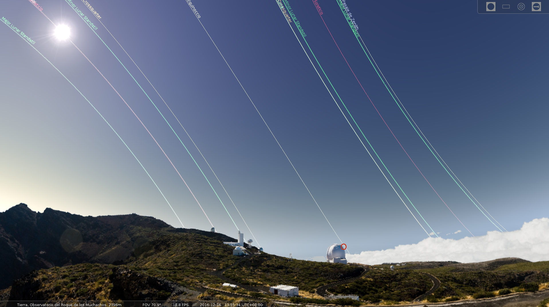
ArchaeoLines plugin together with Roque de los Muchachos’ landscape (source: PROYECTO TARHA).
ArchaeoLines
ArchaeoLines plugin shows the apparent paths of the Sun and the Moon during the equinoxes, solstices and lunar standstills, as well as in crossquarter days. Looking at the intersection of the archaeolines with the landscape loaded, it would be feasible to detect any artificial and / or natural astronomical markers.
Conclusion
To sum up, we can say that the combination of the three functionalities described above make Stellarium a software of great utility for researchers of the ancient sky, both professional and amateur, and from these lines we want to encourage the development of a collection of archeoastronomic landscapes of the Canary Islands.
Antonio M. López Alonso
References
- Arias Marín de Cubas, T. (1937). Historia de la Conquista de las siete Yslas de Canaria. Telde (Gran Canaria): Don Pedro Cabrera Benítez Archive.
- Barrios García, J. (2004). Sistemas de numeración y calendarios de las poblaciones bereberes de Gran Canaria y Tenerife en los siglos XIV-XV. PhD. Thesis. La Laguna (Tenerife): Universidad de La Laguna.
4 comments on “Using Stellarium in Archaeoastronomy”